Info
Currently no avalanche forecast!
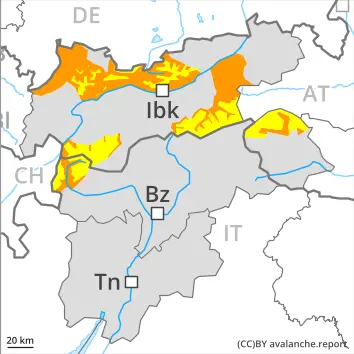
Dangerrating 3 – Considerable
Earlier:
2500 m
Tendency: Constant avalanche danger
am 16. April 2026
am 16. April 2026
2500 m
Snowpack stability:
Poor
Frequency:
Some
Avalanche size:
Large
2500 m
Snowpack stability:
Poor
Frequency:
A Few
Avalanche size:
Large
Later:
3000 m
Tendency: Constant avalanche danger
am 16. April 2026
am 16. April 2026
3000 m
Snowpack stability:
Very Poor
Frequency:
Some
Avalanche size:
Large
2600 m
Snowpack stability:
Poor
Frequency:
A Few
Avalanche size:
Large
An unfavourable avalanche situation will be encountered over a wide area. Wet snow represents the main danger.
Snowpack Structure Highlights
- Danger Patterns
- springtime situation
- deep persistent weak layer
The surface of the snowpack will cool hardly at all during the overcast night. For this reason the snowpack will only just freeze. Sunshine and high temperatures will give rise as the day progresses to increasing and thorough wetting of the snowpack below approximately 3000 m. The high humditiy will give rise in the afternoon to a loss of strength within the snowpack also on steep shady slopes.
West, north and east facing slopes above approximately 2200 m: Towards its base, the snowpack consists of faceted crystals.
The surface of the snowpack will only just freeze and will soften quickly. As the day progresses as a consequence of warming during the day and solar radiation there will be an increase in the danger of wet avalanches.
In the early morning as a consequence of warming during the day and solar radiation there will be a rapid increase in the danger of wet avalanches. Most and wet avalanches can in some places be released by a single winter sport participant. Caution is to be exercised in particular on very steep slopes below approximately 2500 m.
As the penetration by moisture increases the prevalence of the avalanche prone locations will increase as the day progresses. More frequent wet slab avalanches are to be expected in the afternoon. Caution is to be exercised in particular on steep shady slopes between approximately 2200 and 2600 m. Especially here wet avalanches can be released in the weakly bonded old snow and reach large size. This also applies in isolated cases in highly frequented off-piste terrain. In steep gullies the avalanches can reach areas without any snow cover.
Individual avalanche prone locations for dry avalanches are to be found on very steep shady slopes above approximately 2600 m. Such avalanche prone locations are difficult to recognise. Especially transitions from a shallow to a deep snowpack are unfavourable. The small wind slabs are to be evaluated with care and prudence on near-ridge shady slopes in high Alpine regions.