Info
Currently no avalanche forecast!
Dangerrating 3 – Considerable
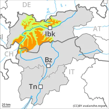
Treeline
Tendency: Danger avalanche increases
am 17. February 2026
am 17. February 2026
Treeline
Snowpack stability:
Very Poor
Frequency:
Some
Avalanche size:
Large
Treeline
Snowpack stability:
Very Poor
Frequency:
Some
Avalanche size:
Medium
The off-piste conditions are dangerous. Wind slabs and weakly bonded old snow require caution.
Snowpack Structure Highlights
- Danger Patterns
- deep persistent weak layer
- buried surface hoar
Over a wide area 15 to 25 cm of snow, and even more in some localities, will fall on Monday. As a consequence of a strong wind from northwesterly directions, avalanche prone wind slabs will form. Somewhat older wind slabs are lying on surface hoar in some places.
The fresh snow and the wind slabs will be deposited on a weakly bonded old snowpack in particular on west, north and east facing slopes above the tree line. Faceted weak layers exist in the bottom section of the snowpack. Stability tests and reports filed by observers confirm the existence of a weak snowack.
Further increase in avalanche danger as a consequence of new snow and wind.
Weak layers in the old snowpack represent the main danger. Natural avalanches are to be expected.
The fresh snow and the wind slabs that are being formed by the strong westerly wind can be released very easily. The avalanche prone locations are to be found in particular in gullies and bowls, and behind abrupt changes in the terrain above the tree line. Individual avalanche prone locations are to be found also in areas close to the tree line.
In some places avalanches can also penetrate near-ground layers of the snowpack and reach large size in isolated cases, in particular on west, north and east facing slopes.
These places are difficult to recognise. Whumpfing sounds and the formation of shooting cracks when stepping on the snowpack and fresh avalanches serve as an alarm indicating the danger. Remotely triggered avalanches are possible.
As a consequence of the snowfall the avalanche prone locations will become more prevalent as the day progresses. Individual natural avalanches are to be expected.
At low and intermediate altitudes small wet loose snow slides are to be expected as a consequence of the rain, in particular on cut slopes, and on very steep grassy slopes.