Info
Currently no avalanche forecast!
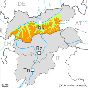
Dangerrating 3 – Considerable
Tendency: Danger avalanche decreases
am 3. April 2026
am 3. April 2026
2200 m
Snowpack stability:
Poor
Frequency:
Some
Avalanche size:
Large
2200 m
Snowpack stability:
Poor
Frequency:
Some
Avalanche size:
Medium
New snow and weakly bonded old snow are to be assessed with care and prudence.
Snowpack Structure Highlights
- Danger Patterns
- cold on warm / warm on cold
- loose snow and wind
The old snowpack will be weakly bonded in some places, especially on west, north and east facing slopes above approximately 2200 m, and on south facing slopes in high Alpine regions.
The sometimes strong wind has transported the fresh and old snow. In some cases the various wind slabs have bonded still only poorly together.
New snow and weakly bonded old snow are to be assessed with care and prudence.
Avalanches can in some cases be released in the old snowpack and reach large size, especially on west, north and east facing slopes above approximately 2200 m, and on south facing slopes at elevated altitudes. Whumpfing sounds and the formation of shooting cracks when stepping on the snowpack can indicate the danger. Remotely triggered avalanches are possible in isolated cases.
The no longer entirely fresh wind slabs can be released by a single winter sport participant above the tree line. Such avalanche prone locations are covered with new snow and are therefore difficult to recognise. Caution is to be exercised in particular at the base of rock walls and behind abrupt changes in the terrain, as well as adjacent to ridgelines and in gullies and bowls. Avalanches can reach medium size.
In addition small and medium-sized loose snow avalanches are possible, in the event of prolonged bright spells especially on extremely steep slopes.