Info
Currently no avalanche forecast!
Dangerrating 2 – Moderate
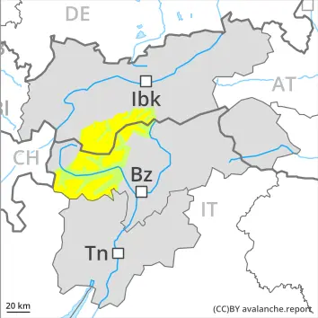
2200 m
Tendency: Danger avalanche increases
am 26. March 2026
am 26. March 2026
2200 m
Snowpack stability:
Poor
Frequency:
A Few
Avalanche size:
Large
Weakly bonded old snow is to be evaluated with care and prudence.
Snowpack Structure Highlights
- Danger Patterns
- loose snow and wind
- shallow snow next to deep snow
Somewhat older wind slabs are lying on the unfavourable surface of an old snowpack, especially on very steep northwest, north and northeast facing slopes above approximately 2200 m, also on very steep west and east facing slopes above approximately 2500 m, as well as on very steep southeast, south and southwest facing slopes in high Alpine regions.
Avalanche prone weak layers exist in the bottom section of the snowpack in particular in shady places that are protected from the wind, especially above approximately 2200 m.
Steep sunny slopes: Sunshine and high temperatures will give rise to moistening of the snowpack.
Increase in avalanche danger as a consequence of new snow and strong wind.
Even single winter sport participants can release avalanches as before. These can in some cases be triggered in near-surface layers and reach medium size. Caution is to be exercised in particular on very steep northwest, north and northeast facing slopes above approximately 2200 m, as well as on very steep west and east facing slopes above approximately 2500 m, in isolated cases also on very steep southeast, south and southwest facing slopes in high Alpine regions. Avalanche prone locations are to be found in gullies and bowls, and behind abrupt changes in the terrain and adjacent to ridgelines.
They are difficult to recognise. Isolated whumpfing sounds can indicate the danger.
Additionally in isolated cases avalanches can be triggered in near-ground layers. The avalanche prone locations are to be found in particular on very steep west, north and east facing slopes above approximately 2200 m. Such avalanche prone locations are rare but are barely recognisable. Especially transitions from a shallow to a deep snowpack are unfavourable. Avalanches can in isolated cases reach large size.
As a consequence of warming during the day and the solar radiation, the likelihood of moist avalanches being released will increase a little on very steep sunny slopes.