Info
Currently no avalanche forecast!
Dangerrating 3 – Considerable
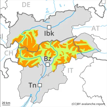
Treeline
Tendency: Constant avalanche danger
am 28. March 2026
am 28. March 2026
Treeline
Snowpack stability:
Very Poor
Frequency:
Some
Avalanche size:
Medium
2200 m
Snowpack stability:
Poor
Frequency:
Some
Avalanche size:
Large
For those venturing off piste a precarious avalanche situation will be encountered over a wide area.
Snowpack Structure Highlights
- Danger Patterns
- loose snow and wind
- deep persistent weak layer
10 to 20 cm of snow, and even more in some localities, has fallen.
The wind was violent in some cases. On Friday the wind will be strong to storm force. The wind will transport the new snow significantly.
The new snow and wind slabs are lying on the unfavourable surface of an old snowpack above the tree line. The old snowpack will be weakly bonded, especially on west, north and east facing slopes above approximately 2200 m, and on south facing slopes at elevated altitudes.
Avalanches can as before be released easily. Restraint is advisable on this first sunny day.
As a consequence of new snow and a storm force northerly wind, sometimes large wind slabs formed in all aspects. In addition further wind slabs will form. These can be released easily. or in isolated cases naturally, above the tree line. Avalanches can be triggered in near-surface layers. Additionally in some places avalanches can penetrate near-ground layers of the snowpack, especially on west, north and east facing slopes above approximately 2200 m.
The danger exists primarily in alpine snow sports terrain. Whumpfing sounds and the formation of shooting cracks when stepping on the snowpack serve as an alarm indicating the danger.
In addition dry loose snow avalanches are to be expected, in the event of solar radiation especially on extremely steep slopes.